Computes a relative differential position at preset time intervals instead of at operator-selected points. Continuous surveying can be interrupted to take observations (a few epochs) at any required way points.
Lock must be maintained to minimum 4 satellites or must be reestablished if lost.
Applications:
road profiling
ship positioning in sounding surveys
aircraft positioning in aerial surveys
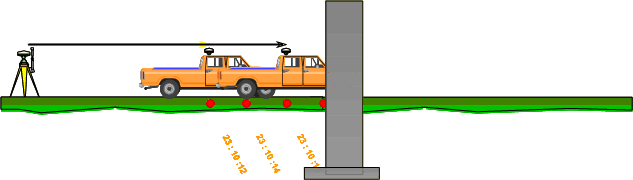
(c) Kinematic On the Fly survey (OTF)
Fixing the integer ambiguity for carrier phases on the fly is at the heart of this process. The method uses widelaning (explained in Lecture 15) which allows increasing the spacing of phase ambiguity making the ambiguity resolution better. The method can be implemented with dual frequency receivers only.
Just like rapid static method, it proceeds as follows (Sickle, 2001):
P code pseudoranges provide for wide laning based integer bias solution which is used, in turn, to solve the base carrier ambiguity.
It, however, differs from rapid static survey since P-code pseudoranges are electronically refined using Kalman filtering (a kind of averaging process improving initial position from which wide lanne and base carrier solution operate giving rise to very accurate and almost instantaneous operation). This process also allows fast ambiguity resolution.
P-code pseudorange based procedure is so fast that it can be achieved while the receiver is in motion. If it loses lock, with OTF it can be re-acquired without stopping.
Moving mode does not require a static initialization. While moving, once the rover is continuously tracking a minimum of 5 satellites on the L1 & L2 for a period of time, the ambiguities can be resolved.
When traveling under an obstruction and loss of lock occurs then ambiguity resolution will re-establish once 5 satellites on L1 & L2 are acquired and tracking is consistent for a short period of time. This technique allows positions to be determined up to the point that the minimum satellites were re-acquired.
Figure 12.7 Kinematic OTF method
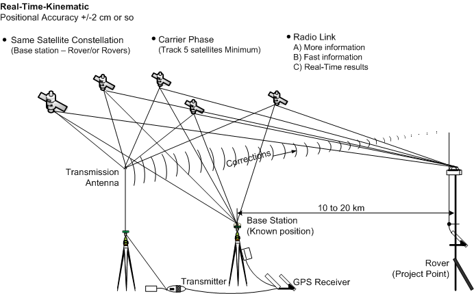
(d) Real time kinematic (RTK) survey
The base station actually transmits correction to the rover using radio link (Figure 12.7).
No post-processing is required and results are obtained almost instantaneously.