Most widely used differential technique for the control and geodetic surveying.
Involves long observation times (1-2 hr, depending on number of visible satellites) in order to resolve the integer ambiguities between the satellite and the receiver.
Accuracies in the sub-centimeter range can be obtained.
(a) Traditional Static Survey
Classical technique which is more accurate, efficient and economical than traditional geodetic methods for long lines for the highest accuracy with following characteristics:
each line is observed for at least one hour
requires more than one receiver and four or more satellites, and unobstructed sky.
long observation time one hour or more (perhaps days) in order to remove ambiguities depending upon
receiver
accuracy requirements
satellites' geometry
length of line
atmospheric conditions
Standard method for lines over 20 km and generally the only solution for large areas.
Accuracy : Provides accuracies of the order of 1:100,000 to 1:5,000,000; For example, typical accuracies can be ± 1 ppm for 1 km baseline, ± ( 5 mm + 1 ppm) for 10 km baseline; ± (3 mm + 0.5) ppm using Choke-Ring Antenna
It may be noted that static surveys surveys generate large volume of data through which high level accuracy is achieved immediately (in a matter of seconds, even by using a single epoch). However, ambiguity resolution may take long sessions.
In such surveys, one may be required to set various parameters such as start and stop time, mask elevation angles, data file names, reference positions, band width, sampling rate, etc. (Sickle, 2001).
Applications
Geodetic control over large areas
National and continental networks
Monitoring tectonic movement
Network adjustments for highest accuracy
Photogrammetric control for aerial surveys and precise engineering surveys
Uses single (for baselines up to 25 km where biases at the end of lines are likely to be similar) or dual frequency receivers (to minimize ionospheric errors) with more channels.
It is considered as the most reliable approach when the available geometry of satellites is not compatible with other GPS techniques.
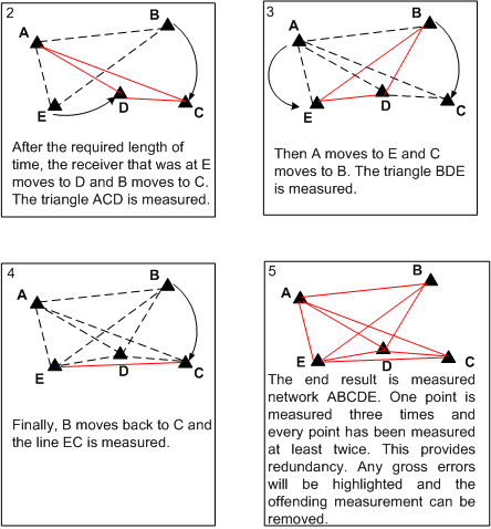
Figure 13.1 shows typical static survey operation in which a network ABCDE is to be measured. The coordinates of point A are knwon in WGS-84 (the reference point). The initial set up of receivers is at A, B, and C.
Figure 12.1 Example of atypical static survey (GPS Basic, 2001)