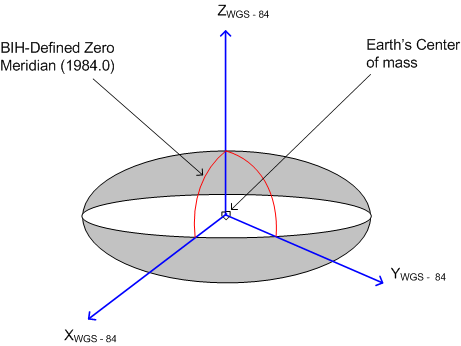
Module 2 : Global Positioning System
   Lecture 8 : More on GPS principles
Coordinate System for GPS
  • Global Positioning System provides coordinates in a global geocentric geodetic reference system known as the World Geodetic System-84 (WGS-84 ).
  • WGS-84 ellipsoid provides worldwide best fit to the geoid in which the coordinates are expressed in either geographical coordinates latitude, longitude and height or geocentric coordinates X, Y and Z.
  • Maps and coordinates in India are in a local geodetic reference system, based on Everest spheroid which is called Indian Geodetic System. The coordinates in the Indian Geodetic System may differ by as much as a few hundreds of meters as compared to the WGS-84 coordinates.
The WGS-84 Coordinate System is a Conventional Terrestrial Reference System (CTRS) whose definition follows the criteria outlined by the International Earth Rotation Service (IERS) Technical Note 21 as give below (NIMA, 2000):
  • It is geocentric, the center of mass being defined for the whole Earth including oceans and atmosphere
  • Its scale is that of the local Earth frame, in the meaning of a relativistic theory of gravitation
  • Its orientation was initially given by the Bureau International de l'Heure (BIH) orientation of 1984.0

Figure 8.7 WGS-84 Coordinate system


The WGS-84 Coordinate System is a right-handed, Earth-fixed, orthogonal coordinate system with the following properties

Origin                At Center of Gravity of the Earth
Z-Axis              The direction of the IERS Reference Pole (IRP). This direction corresponds to the direction of the BIH Conventional
                          Terrestrial Pole (CTP) (epoch 1984.0)
X-Axis               Intersection of the IERS Reference Meridian (IRM) and the plane passing through the origin and normal to the Z-
                          axis. The IRM is coincident with the BIH Zero Meridian (epoch 1984.0)
Y-Axis               A right-handed, Earth Centered, Earth Fixed (ECEF) orthogonal coordinate system, measured in the plane of the
                          Conventional Terrestrial Pole (CTP) Equator, 90° East of the X-Axis.

Some useful parameters for WGS-84 are listed in Table 8.1. For more details on WGS-84, one can refer to WGS-84

 
Table 8.1 WGS 84 parameters (NIMA, 2000)
Parameters
Notation
Value
Semi-major axis
a
6378137.0 m
Semi-minor axis
b
6356752.3142 m
Reciprocal of flatening
1/f
298.257223563
Angular velocity of earth
ω
7292115.0 x 10-11 rad/s
Earth's gravitational Constant (mass of earth included)
GM
73986004.418 x 108 m3/s2
First eccentricity
e
8.1819190842622 x 10⁻²
second eccentricity
e'
8.2094437949696 x 10⁻²