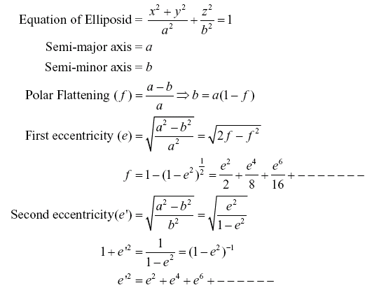
| Background for
Coordinate System |
- Well-defined coordinate systems are required for positioning
points in 2D or 3D space on surface of earth. However, one
needs to represent or idealize earth in a manner suitable
for proper representation of position. Several idealizations
have been proposed for the shape of earth.
- For example, the first approximation
to shape of earth is Geoid, the theoretical shape of earth. Differences in
the density of the earth cause variation in the strength
of the gravitational pull, in turn causing regions to dip
or bulge above or below a mathematical reference surface
called ellipsoid. This undulating shape is the Geoid. The
geoid is very irregular and the magnitude of geoidal deformation
depends on the variation in the strength of the magnetic
field, and on geologic history.
- A rotational ellipsoid is
another mathematical approximation to earth's shape. It
is an imaginary, regular and smooth mathematical surface
over which computation of coordinates becomes very easy.
An ellipsoidal surface can be further approximated by a sphere.
|
| Figure
8.5 gives the most important surfaces from the view point of
positioning – the
actual earth’s
surface, and its approximation in the form of geoid and ellipsoid.
The separation between ellipsoid and geoid is indicated by
Geoidal undulation (N). The normal distance earth’s surface
and geoid is called orthometric height (H). The normal distance
earth’s surface and ellipsoid is called the geodetic
height (h). An approximate relationship between these quantities
is given by
h = H + N
Since geoid is also very irregular,
it is approximated by another surface called mean sea level
(MSL).
|
|
|
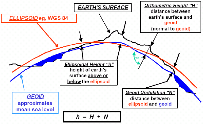
Figure 8.5 Important surfaces for positioning
|
- As the actual earth
surface is highly undulating, defining position on this surface
is quite difficult. We use the concept of datum which
is a mathematical model of the earth we use to calculate
the coordinates (2D or 3D) on any map, chart, or survey
system. The datum can be vertical – to define vertical position
(Z) with respect to a reference surface or horizontal – to
define the horizontal position (X and Y). Geoid is used for
representation of land and ocean surface topography and can
be defined as that surface which best fits the MSL. The MSL
is generally used as the reference surface for heights or
as the vertical datum. Using conventional survey equipment
which make use of plumb bob and bubble tube to establish
directions of gravity and level surface, one can easily realize
the difference in heights between two points However, even
this surface (MSL) is also not smooth enough for representation
of horizontal coordinates. Hence, separate horizontal datums,
also called as the geodetic datums are used
for horizontal
positioning.
- Geodetic datums define the size and shape of the earth
and the origin and orientation of the coordinate systems
used to map the earth. Modern geodetic datums range from
flat-earth models used for plane surveying to complex models
from spherical earth to ellipsoidal
models and derived from years of satellite measurements.
These are used for many applications which completely describe
the size, shape, orientation, gravity field, and angular
velocity of the earth. A typical coordinate system for
horizontal geodetic datum is given in the Figure 8.6:
|
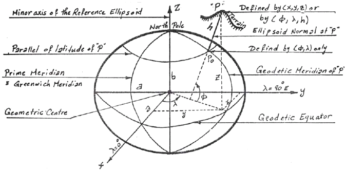
Figure 8.6 A typical elliposidal coordinate system (Nassar,
1994)
|
| It
can be seen that the coordinates of a point P in this system
can be expressed in two ways - curvilinear (longitude: l ,
Latitude: f ,
Geodetic height: h) and rectangular (x, y, z). Standard
formulae are available for converting from curvilinear
to rectangular and vice versa (Wolf and Ghilani, 2002).
A few useful geometrical relationships for the above system
are given below: |
|
- The
ellipsoidal systems can be geocentric or non-geocentric.
The geocentric systems have their z-axis aligned either
(a) with the instantaneous spin axis of the earth (instantaneous
terrestrial system, ITS) or (b) with a hypothetical spin
axis adopted by a convention (conventional terrestrial
systems, CTS). Such systems became useful only quite recently,
with the advent of satellite positioning. The World
Geodetic System-84 (WGS-84) is one
such system which is the global system for defining coordinates
for GPS measurements.
- The non-geocentric systems are
used for local work (observations) in which case their
origin would be located at a point on the surface of
the earth. For near-geocentric
systems, origin is usually as
close to the center of mass of the earth as the earlier
geodesists could establish. Such systems are off the
center of mass by anything between a few meters and a
few km (more than 100 such systems are in existence around
the world). These associated reference ellipsoids are
taken to be concentric with their coordinate system,
geocentric or near-geocentric, with the axis of revolution
coinciding with the z-axis of the coordinate system.
Indian Everest system,
on which all our topograpic mapping is based, is an example
of such local geodetic system whose initial point or
tie point is located at Kalyanpur (MP, India).
|
|
|