Pseudorange is a measure of distance between satellite
and the receiver' antenna, referring to the epochs (time)
of emission and reception of codes.
The transmission (travel) time is measured by correlating identical
PRN codes generated by the satellite with those generated
internally by the receiver.
Various errors such as the satellite and receiver clocks
offset, atmospheric delay, multipath etc. tend to corrupt
the true range (also called as the geometric range) measurement
to produce what is called as the pseudorange.
Clock offset can be computed
so that relative time of transmission
and reception of a radio signal is known (T).
With the known velocity of radio wave and by precise measurement
of time of travel, the distance/range (D) can be computed
as: D = C x T
Since coordinates of the satellite are known at any point
in time, the position of receiver antenna can be computed.
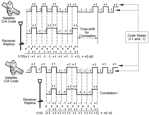
Figure 8.1 explains the basic principle involved in distance
calculation. Distance to the satellite is measured using
code sent from the satellite.
The same
code (replica) is generated simultaneously in the receiver.
Travel
time of signal can be measured from this corresponding to
a time tag where the maximum correlation is
observed. The distance is calculated by using this time marker
by multiplying with the speed of light (Sickle, 2001).
Figure
8.1 Code correlation measurement : Low Accuracy 1 to 5 m
(Sickle, 2001)
In code based positioning, four unknowns are identified:
- Three position coordinates ( X, Y, and Z)
- Receiver clock error, dT.
Hence, four equations are needed to solve for these four unknowns, for more number of equations, a least squares solution is carried out.
Where
X n, Yn ,
and Zn Satellite
position coordinates; n varies from 1 to 4 X, Y, and Z GPS
receiver position coordinates Pn Measured
range
c Velocity
of EMR