It has primary application in real time navigation systems where accuracies of the order of ± (0.5 to 5 m) are tolerable. Hence, only limited engineering survey applications of the technique. Example: hydrographic survey and dredge positioning.
Two types of code based positioning:
Single point positioning (SPP)
Differential positioning
Single point positioning (SPP)
Achieved by intersecting the measurements from four or more satellites at a single receiver on the earth's surface almost instantaneously, using an inexpensive hand-held GPS receiver and by collecting C/A code measurements.
Differential positioning
Significantly reduces errors affecting single point positioning through relative positioning.
It is the most simple form of relative positioning which can be conducted by:
applying corrections to the code measurements sensed at a known monitor site, to the measurements at an unknown rover site.
using either simpler and cheaper post-mission (post-processed DGPS) or complex real-time processing needing data link (real time DGPS).
Real time DGPS is somewhat limited to near line of sight conditions, whereas post-mission DGPS allows meter or sub-meter positioning up to 300 km and mostly used for GIS applications.
Real time DGPS
It is a code based relative positioning that employs two or more receivers simultaneously tracking the same satellites. The GPS processing software takes the difference between computed ranges and the measured code pseudoranges to obtain DGPS corrections.
DGPS corrections (based on L1 pseudorange) are transmitted in a standard RTCM (Radio Technical Commission for Maritime Service) format, accepted by GPS industry as the standard, to the rover through a communication link.
RTCM message type for differential GPS typically consists of
Reference Station Parameters
Pseudorange Corrections
Range Rate (rate of change of range) Corrections
Rover applies these corrections to measure correct pseudoranges at the rover so as to compute the rover coordinates.
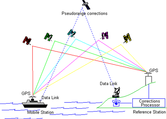
In real time DGPS following observations are in order at the reference and rover station (Figure 12.5: At reference station
Reference station on a known point
Tracks all satellites in view
Computes corrections for each satellite
Transmits corrections via a communication link in either propriety format or the RTCM (Radio Technical Commission for Maritime Service) format
At the rover station
Rover unit receives the corrections via the communication link
Rover position corrected by applying the received corrections