Module 2 : Global Positioning System
  Lecture 11 : Satellite geometry and Accuracy measures
Absolute and relative accuracy
Accuracies can be expressed as absolute or relative (GPS Positioning Guide, 1995)
Absolute accuracies : These are estimates of how close a position is to the truth in the earth's reference frame. Absolute accuracies are always represented as constant values.
Example: Horizontal positions determined by GPS single point positioning, assuming favourable satellite geometry, are accurate to 100 m at 2DRMS horizontally and 156 m at 2σ level vertically (U.S. DoD and DoT, 1986).
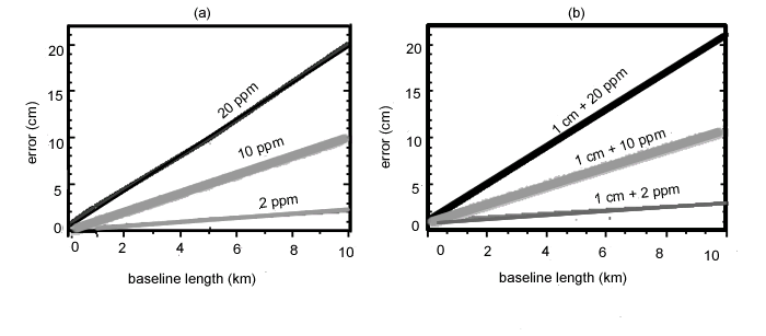
Relative accuracies: These are estimates of how well a vector between two points is measured (e.g. the accuracy of a distance measurement between two points). Relative accuracies may be represented as constant values, as parts per million (ppm), or both. Parts per million are used to relate error magnitudes with baseline length.
Example : 1 ppm corresponds to a 1 mm error over 1 km and a 1 cm error over 10 km. The linear relationship between errors and baseline distance for 2, 10 and 20 ppm is shown in Figure 11.6.
 
Baseline accuracies using GPS are often expressed combining a constant term (e.g. 1 cm) with a linear term (e.g. 1 ppm). For example, the accuracy of a precise survey could be specified in a similar manner as measured from EDM as given below:
RMS accuracy = 1 cm + 1 ppm
In GPS, the constant term accounts for errors which are independent of baseline length such as antenna set-up and multipath errors, while the linear term accounts for length dependent errors such as residual orbital, tropospheric and ionospheric errors.
 

Figure 11.6 Relative accuracies (GPS Positioning Guide, 1995)

Figure 11.7 gives a diagramatic representation of magnitude of errors in different types of GPS surveys (static, kinametic, phase based or code based, point positioning or differential positioning). These methods will be explained later.
Figure 11.7 Error levels in different survey methods