Lecture 11 :
Satellite geometry and Accuracy measures
Satellite geometry
and accuracy measures
GPS positioning accuracy is a function of two factors (Seeber, 2003):
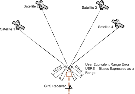
User Equivalent Range Error
(UERE) or associated standard deviation ( σr):
Measure of the accuracy of single pseudorange measurements.
When each type of error or bias is expressed as
a range itself, each quantity is known as UERE and
expresses the individual contribution of each bias
to the overall error and gives the accuracy of individual
range measurements to each satellite (Figure 11.1).
Geometry of satellites used in computation or Dilution of Precision (DOP):
GPS ranging errors are magnified
due to geometrical arrangement amongst
the range vectors between the receiver and the
satellites. It is a quality indicator of the
results that can be expected from a GPS point
position.
It solely
based on the geometry of the satellites and therefore
can be computed without any pseudorange observations
being recorded. It is equivalent to the concept
of strength
of figure used in surveying and
varies rapidly with time since satellite are
moving control points.
Relationship between σr and the associated standard
deviation of positions ( σ* ) is given by
the following relationship
User Equivalent Range Error UERE
The combined effect of ephemeris uncertainties, propagation
errors, clock and timing errors, and receiver noise, projected
on to the line connecting the observer and satellite is called
the User Equivalent Range Error (UERE) or User Range Error
URE.
Sometimes total error is divided as (Seeber, 2003):
Signal in Space (SIS) URE
(abbreviated as SISRE):
Operational Control Segment (OCS) is responsible
for this group of error.
Includes satellite clock and ephemeris prediction
errors, OCS state process noise, and minor residual
error.
User Equipment Error (UEE):
Particular user's equipment and correction model
is responsible for this group of errors.
Includes single frequency ionospheric model error,
tropospheric model error, receiver noise, receiver
phase centre variation, or multipath effects.
Figure 11.1 UERE
in GPS measurements (Sickle, 2001)