| Example 2:
|
| The following data is given for flight planning:
|
- Format 18 x 18 cm
- Focal length = 21 cm
- Scale = 1/20,000
- Longitudinal overlap = 60%
- Lateral overlap = 20%
- East-west terrain length = 100 km
- North-south terrain width = 50 km
- Flight direction: East to west
- Aircraft velocity = 296 km
- Permissible image movement = 0.02 mm
- Wind velocity = 10 m /s from SSE direction
|
| Calculate the following
|
- Exposure interval
- maximum exposure time
- Ground speed of aircraft
- Drift angle
|
| Solution
|
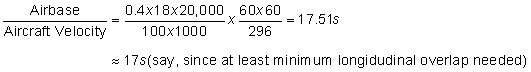
- Airbase = 0.4 x 18 cm at photo scale. On ground
|
|
| |
|
- Image movement = 0.02 mm on photo. On ground,
|
|
- Time taken to cover this distance = maximum exposure time (shutter speed)
|
|
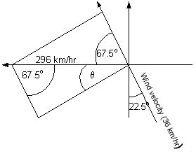
- Wind speed = 10 m/s = 36km/hr; flying speed = 296 km/hr. The ground speed of the aircraft and the angle of drift can be found out by vector operations.
Effective ground speed = (2962 + 362 - 2x296x36xcos67.5) 1/2 = 284.176 km/hr.
|
- Drift angle ( θ ) is given as
|
|
|
| |