Module 3 : Photogrammetry
  Lecture 21 : Flight planning
Examples
The overall flight planning procedure can be understood by a few simple examples that follow.
 
Example 1 :

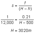
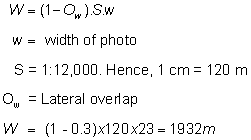
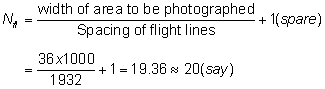
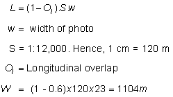
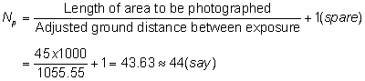
An area 45 km long and 36 km wide is to be photographed to an average scale of 1:12000, using an aerial camera of f = 21 cm. The speed of the aircraft is 200 km/h. The photographs are 23 cm square, with a longitudinal overlap of at least 60% and lateral overlap of 30%, average elevation of the terrain is 500 m above MSL. Calculate the following:

  • The flying height above mean sea level (MSL).
  • Distance between successive exposures
  • Distance between flight lines for successive strips.
  • Flight line spacing on flight map at a scale of 1 cm = 600 m
  • Interval between successive exposures
  • Number of photographs per strip taking one extra photograph at either end
  • Number of strips with only one extra strip as a safety factor
  • Total number of photographs
 
Solution:
  • The flying height (H) can be calculated by using
  • Spacing of the flight line (W)
  • Number of flight lines (N fl ) required
  • Actual spacing between flight lines
  • Spacing of the flight lines on a flight map
  • Ground distance between exposures
  • Exposure interval

Since required overlap is at least 60%, hence exposure interval can be kept as 19 seconds.

  • Adjusted ground distance between exposures
    L = 55.55 x 19 = 1055.45 m
  • No. of photographs per flight line (N p )

Allowing two extra photographs at each end, the total photographs per flight lines = 44 + 2 + 2 = 48.

  • Hence, total no. of photographs = 48 x 20 = 960