|
Intelligent Transportation Systems (ITS) is the application of computer,
electronics, and communication technologies and management strategies in an
integrated manner to provide traveler information to increase the safety and
efficiency of the surface transportation systems.
These systems involve vehicles, drivers, passengers, road operators, and
managers all interacting with each other and the environment, and linking with
the complex infrastructure systems to improve the safety and capacity of road
systems.
As reported by Commission for Global Road Safety(June 2006) , the global
road deaths were between 750,000 to 880,000 in the year 1999 and estimated
about 1.25 million deaths per year and the toll is increasing further.
World health organization report (1999), showed that in the year 1990 road
accidents as a cause of death or disability were the ninth most significant
cause of death or disability and predicted that by 2020 this will move to sixth
place.
Without significant changes to the road transport systems these dreadful figures
are likely to increase significantly.
Traditional driver training, infrastructure and safety improvements, may
contribute to certain extent to reduce the number of accidents but not enough to
combat this menace.
Intelligent Transport Systems are the best solution to the problem.
Safety is one of the principal driving forces behind the evolution, development,
standardization, and implementation of ITS systems.
ITS improves transportation safety and mobility and enhances global
connectivity by means of productivity improvements achieved through the
integration of advanced communications technologies into the transportation
infrastructure and in vehicles.
Intelligent transportation systems encompass a broad range of wireless and wire
line communication based information and electronics technologies to better
manage traffic and maximize the utilization of the existing transportation
infrastructure.
It improves driving experience, safety and capacity of road systems, reduces
risks in transportation, relieves traffic congestion, improves transportation
efficiency and reduces pollution.
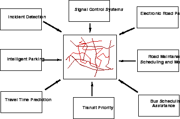
In order to deploy ITS, a framework is developed highlighting various services
the ITS can offer to the users.
A list of 33 user services has been provided in the National ITS Program Plan.
The number of user services, keep changing over time when a new service is
added.
All the above services are divided in eight groups.
The division of these services is based on the perspective of the organization
and sharing of common technical functions.
Some of the user services offered by ITS are shown in
Fig. 1.
The eight groups are described as follows:
- Travel and traffic management
- Public transportation operations
- Electronic payment
- Commercial vehicle operations
- Advance vehicle control and safety systems
- Emergency management
- Information management
- Maintenance and construction management
Figure 1:
ITS user services
 |
The main objective of this group of services is to use real time information on
the status of the transportation system to improve its efficiency and
productivity and to mitigate the adverse environmental impacts of the system.
This group of user service is further divided in 10 user services.
Most of these services share information with one another in a highly integrated
manner for the overall benefit of the road transportation system.
These services are described as below:
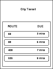
This user service provides information to the travelers about the transportation
system before they begin their trips so that they can make more informed
decisions regarding their time of departure, the mode to use and route to take
to their destinations.
The travelers can access this information through computer or telephone systems
at home or work and at major public places.
Pre travel information can be accessed through mobile phones as shown in
Fig. 2.
Different routes and respective travel time durations indicated on VMS are shown
in Fig. 3.
The information include real time flow condition, real incidents and suggested
alternate routes, scheduled road construction and maintenance tasks, transit
routes, schedules, fares, transfers, and parking facilities.
Figure 2:
Pre trip information
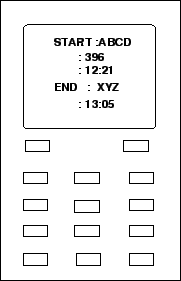 |
Figure 3:
VMS showing routes
 |
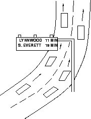
This user service provides travel related information to the travelers en route
after they start their trips through variable message signs (VMS), car radio,
or portable communication devices.
Fig. 4 shows the various congested and non congested
routes shown on display screen.
VMS indicating different routes and travel time is shown in
Fig. 5.
This helps the travelers to better utilize the existing facility by changing
routes etc to avoid congestion.
This also provides warning messages for roadway signs such as stop signs, sharp
curves, reduced speed advisories, wet road condition flashed with in vehicle
displays to the travelers to improve the safety of operating a vehicle.
The information can be presented as voice output also.
Figure 4:
Showing congested routes
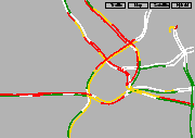 |
Figure 5:
VMS showing routes and travel times
 |
|
|