3.2.2 Methods for landfill site selection
There are different qualitative and quantitative methods available for landfill site selection by assessing the extent of environmental impact caused by the project. Essentially the decision on landfill site is done based on subsurface and burrow source investigation. The subsurface investigation includes the assessment of hydrogeology of a place to understand permeability, strength, compressibility, contaminant interaction, presence of faults and folds, seismic hazard investigation etc. Borrow source investigation reveals the quality of material available near to the probable landfill site and its utility in landfill construction. If soil near by is suitable, it would considerably reduce the cost of the project by minimizing transportation and material expenditure. Some of the qualitative and quantitative methods for landfill site selection are briefly discussed below. Qualitative methods for landfill site selection are used only for preliminary evaluation as discussed below:
(a) Check list: It is a simple list consisting of different criteria that are important for knowing potential impact due to a project on the environment. It includes factors related to environment, social and ecosystem considering its beneficial or adverse impact. For instance:
- Population likely to be affected by project.
- Soil, air, water.
- Flora and fauna
- Land use etc.
A descriptive check list gives list of impacts during the various stages of project which can be used as criteria for understanding environmental impact. A weight scale check list is used to recognize the relative importance of different factors or environment.
(b) Network analysis: In this method, cause and effect relationship is detected by analyzing different areas likely to be affected by the project. A block diagram shown in Fig. 3.4 is used to show the connectivity between action and consequence. The connectivity is shown by solid arrow for direct consequence and broken for indirect consequence. It provides an effective and visual way to illustrate positive or adverse impacts of a project.
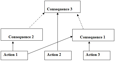 |
Fig 3.4 Network analysis block diagram (Munier 2004) |
(c) Overlays: In this method, thematic transparent maps are developed for flora, fauna, geology, population, rivers, slopes, roads, agricultural land etc. These maps are placed on a glass table, one on top of the other, forming layers of information about the zone .When an intense electric lamp is placed beneath the glass table, light reaching the top layer indicate the area that is feasible for a project under study. The physical limitation in the application of this method is that no more than 10 overlays can be used. These days GIS (geographic information system) is an effective quantitative method to combine the overlays.
Some of the quantitative methods for landfill site selection include the following:
(a) Matrix method
This method relates activities of a project and its impact on the environment. An example problem of site selection for landfill is presented in Table 3.1. The table corresponds to the assessment of one of the alternative (Site 1). As listed in the table, an importance value is assigned to different environmental parameters. Further, the impact of different activities (denoted as A, B, C, D in table) on these environmental parameters is defined by assigning magnitude of impact, which can be negative or positive. A, B, C, D corresponds to activities like disposal of solid waste, reclamation, transportation etc.
Table 3.1 Details of matrix method |
|
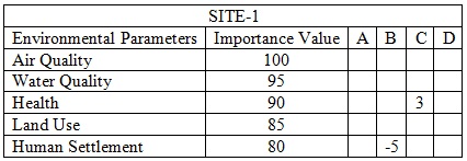
A matrix is formed by assigning importance values to the environmental parameters selected for the problem. Further a value is assigned in the matrix which shows the magnitude of impact (positive or negative depending upon the sign of magnitude) due to the activity on the environment. Importance values are multiplied with magnitude of impact and summation is done for rows as well as for columns. Best site is then decided based on the maximum summation value of row, column or both.