To find accurate relative elevations of two widely separated intervisible points (between which levels cannot be set), reciprocal leveling is being used.
To find the difference in elevation between two points, say X and Y (Figure 15.1), a level is set up at L near X and readings (X1 and Y1) are observed with staff on both X and Y respectively. The level is then set up near Y and staff readings (Y2 and X2 ) are taken respectively to the near and distant points. If the differences in the set of observations are not same, then the observations are fraught with errors. The errors may arise out of the curvature of the earth or intervening atmosphere (associated with variation in temperature and refraction) or instrument (due to error in collimation) or any combination of these.
The true difference in elevation and errors associated with observation, if any, can be found as follows:
Let the true difference in elevation between the points be rh and the total error be e. Assuming, no error on observation of staff near the level (as the distance is very small)
Then, rh = X1 ~ (Y1 - e) [From first set of observation]
and rh = (X2 - e) ~ Y2 [From second set of observation]
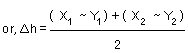
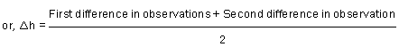
Thus, the true difference in elevation between any two points can be obtained by taking the mean of the two differences in observation.
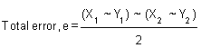
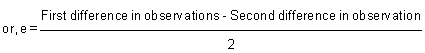
Thus, total error in observations can be obtained by taking the difference of the two differences in observation. The total error consist of error due to curvature of the earth, atmospheric errors (due to temperature and refraction) and instrumental errors (due to error in collimation) etc.